| HOME > Outline of Research |
Understanding the Earth's Environmental System |
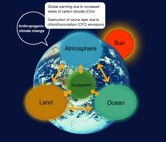
| The Earth’s environmental system is affected by solar activity, geomagnetic fields, material cycles in the atmosphere-ocean-land system, changes in ecosystem and other processes. Investigating the driving mechanisms and processes of past environmental changes using marine cores will help us to understand the natural variability of the Earth’s environment. This will be the key to predicting future climatic changes. |
Environmental Information from the Sedimentary Record |
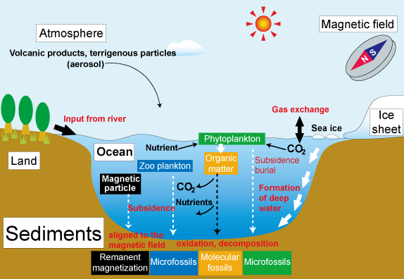
Oceans are an important area of the Earth, because seawater has the potential to absorb greenhouse gases such as carbon dioxide from the atmosphere. The dissolved carbon dioxide in seawater is then consumed by marine phytoplankton for photosynthesis. Organic compounds and plankton produced in the surface waters eventually sink through the water column where some may be decomposed or dissolved during subsidence resulting in inputs of nutrients and carbon dioxide into the intermediate and deep waters. The remainder arrives at the sea floor and is preserved in sediments. Terrestrial materials and aerosols are also transported to the ocean via atmospheric circulation and/or river inputs. Using multidisciplinary approaches such as geochemistry, micropaleontology and paleomagnetism applied to the sediments, we can investigate past material cycles and oceanographic changes in the ocean.
Oceans cover 70% of the Earth’s surface and sediment cores have been taken from most of the world's oceans. They have provided us with global knowledge of the past climate. Deep sea drilling vessels can recover marine sediment cores several hundreds of meters long beneath the sea floor. In general, drilling at sea utilizes the same techniques as those on land, but there are various difficulties involved. For example, several kilometers of pipes need to be extended from a ship to the sea floor prior to drilling.
In the Ocean Drilling Program (ODP), drilling beneath the sea floor is only possible to ~ 2 km deep. Recent progress in Earth sciences requires deeper drilling to investigate current research issues. The United States., Japan and European countries started an international scientific project, the ‘Integrated Ocean Drilling Program’ (IODP) in October 2003. IODP explores the Earth by utilizing multiple drilling platforms: Japanese D/V Chikyu, the U.S. D/V Joides Resolution, and the European Mission Specific Platform (MSP). Chikyu is capable of drilling up to 7,000 m beneath the sea floor which allows us to drill into the mantle. |
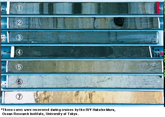
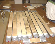
Marine cores are columnar geologic samples (usually sediments) which are taken from beneath the deep sea floor by research vessels and drilling vessels. They are good records of past global environmental changes such as sea level change, paleomagnetic fields, ocean circulation, and sea water temperature.
●Examples of marine cores
The types of deposited sediments and their grain sizes differ with recovery area
(water depth, environment and so on).

Where are these seven cores taken from? Try and match the Core Number and the Recovery Area. The answer is shown on the following page.<click!> |
| Number |
|
Recovery area, types of sediments and water depth |
|
1
2
3
4
5
6
7 |
 |
a. Sulu Sea (Equatorial Pacific), calcareous ooze, 2,993 m
b. Arabian Sea (Gulf of Aden),calcareous ooze, 1,184 m
c. Southern Ocean (Antarctic Ocean), diatom ooze, 3,358 m
d. Japan Sea (Toyama Bay),laminated sediments, 2,373 m
e. East China Sea (Okinawa Trough),
hemipelagic sediments, 1,709 m
f. Arabian Sea (Gulf of Aden), calcareous ooze, 1,474 m
g. Japan Sea (Toyama Bay), color alternation, 2,436 m |
Faculty staff and post-graduate students of the Center join research cruises which are planned to take cores. Such cruises are often operated by the JAMSTEC research vessels, for example, the R/V Hakuho-Maru, Tansei-Maru and Mirai. We have joined many research cruises.
Cores are taken from the ocean floor using equipment called a ‘piston corer’ and a ‘multiple corer’. |
Flowchart of core analysis |
Step 1. Non-destructive Measurements
Non-destructive measurements such as X-ray CT scanning of the core samples provide sequential digital data about sediment structure and physical properties prior to detailed invasive analyses. The provisional dataset gives us general information from which a subsequent sampling strategy can be formulated.
Step 2. Sampling
After the non-destructive measurements, each section of the core is halved longitudinally using a core cutter or wire. One of the halves is called the ‘working half’ which is sampled at certain depth intervals for further analysis, while the other half, called the ‘archive half’, is kept in the core repository in reserve.
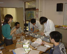
Step 3. Analyses and measurements
Individual samples taken from the working half of the cores are sent to each laboratory (micropaleontology, physical properties, sedimentology, paleomagnetism, organic chemistry, inorganic chemistry, and microbiology) for detailed observations, analyses or measurements.
Step 4. Storage
Cores are stored in refrigerators or freezers. The core repository continuously monitors temperature and humidity to avoid any fluctuations, so that the archive halves are kept in good condition. For microbiological samples, ultra cold conditions are necessary to prevent them from oxidation and chemical breakdown. |
 |
|